06/23/2021
 Late-August through mid-October is always a hectic and busy time for farmers in the Red River Valley, at the border of North Dakota and Minnesota. Seasonal workers from all over the country converge onto dozens of campgrounds, while thousands of trucks criss-cross the plains along the river every day. The reason behind all this activity? The sugar beet harvest at the American Crystal Sugar Company (ACSC). SatAgro developed a satellite data-based system to help keep track of this immense operation’s progress.
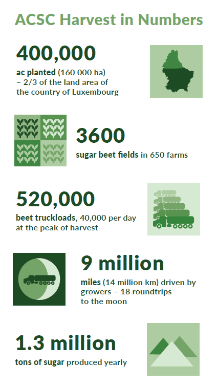
The ACSC is a cooperative consisting of 650 growers who altogether plant over 400 000 acres (160 000 hectares) of sugar beets every year. All in all, the ACSC grows over 35% of all sugar beet acres in the United States. Why the region is so well suited to growing beets can be boiled down to three factors. “10,000 years ago this area was the bottom of a glacial lake, which gives us deep, rich soils that require no irrigation. The soil is our water reservoir” explains Joe Hastings, General Agronomist at the ACSC. “Due to our far North latitude, we have long summer days which help increase the beet root’s sugar reserves. Cold winters on the other hand benefit storage so we can process the crop longer without spoilage.”
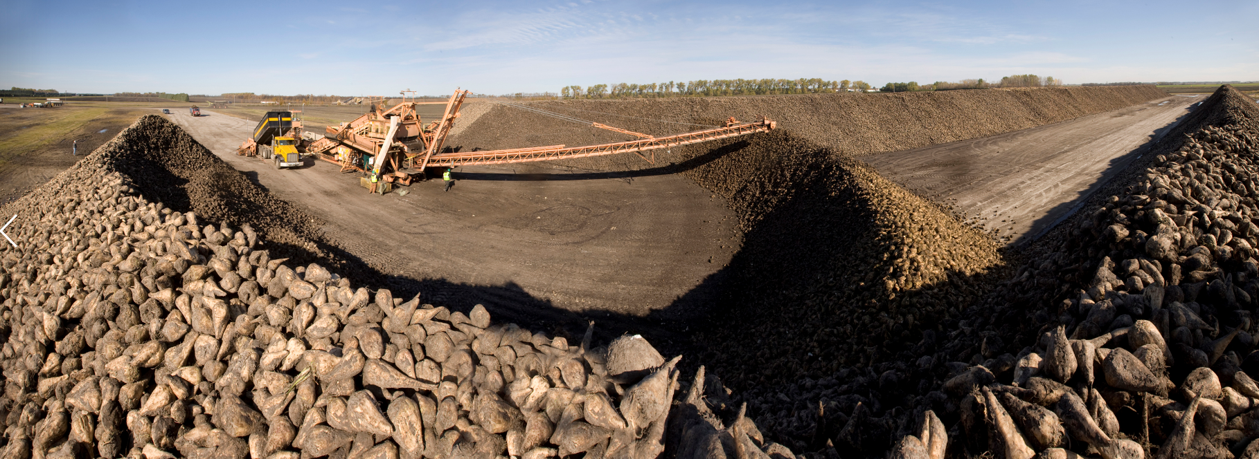
Starting in mid-August, growers begin harvesting small strips of their fields to satisfy the daily demand of 5 beet processing plants, while the rest of the crop remains in the ground to gain beet mass. It is early October when the harvest really picks up speed. With the approaching mid-western winter frost, a race against time begins to get the year’s yield out of the ground and onto ACSC’s piling sites. During the height of this harvest stage, the daily sugar beet delivery exceeds a million tons. For more harvest numbers, see the insert to this article.
So how do you keep track of the largest movement of raw agricultural products in the world? “Covering 400,000 acres of sugar beet production in real-time is a challenge” says Joe Hastings. “Having the ability to monitor harvest progress and crop size is critical to managing our assets and resources”.
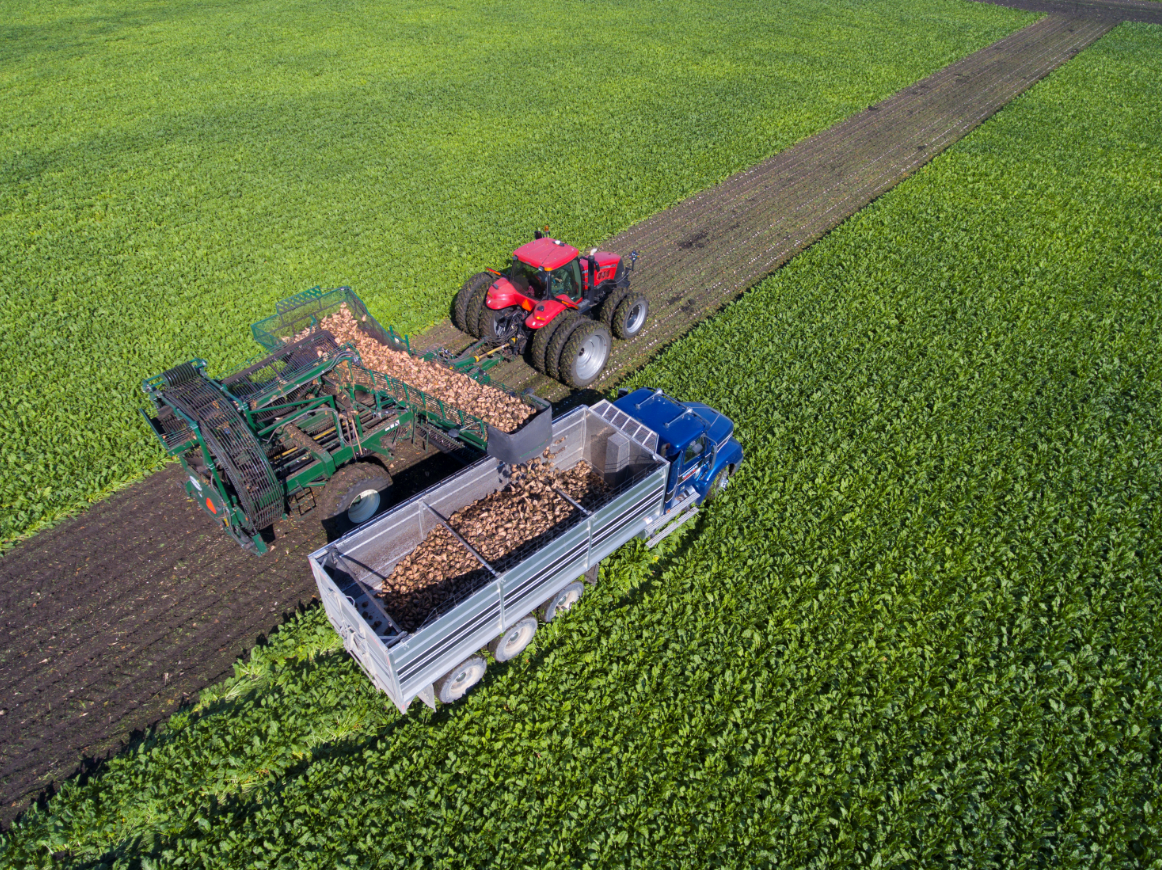
Image credit: ACSC
If you do not want farmers to spend more time on reporting their every move than on actually tending to their crop, satellite data can be of help. As SatAgro’s Chief Development Officer Przemyslaw Zelazowski says, “satellite data combine a very low cost of information acquisition with high accuracy”.
It is with this idea – a way of monitoring the harvest progression of the entire Red River Valley sugar beet crop at a glance – that the ACSC’s Agronomy Department approached SatAgro in early 2020. The issue was particularly salient in the wake of the 2019 harvest season, when intense rain in the region prevented over 30% of the crop from being harvested.
The satellite Earth Observation sector has matured to the point where the entire globe is frequently captured on imagery from public and commercial data providers. However, “traditional” optical data alone would not be sufficient to accurately capture the Red River Valley harvest. As Stefan Jozefowicz, Project lead at SatAgro, says, monitoring the region using satellites poses challenges “similar to other temperate climate regions around the globe – most importantly prolonged periods of consistent cloud cover”. At the crucial stage of harvest, skies over the Valley are often overcast – getting a clear view of the terrain requires some luck. In fact, most logistics challenges happen during bad weather, so often the most needed image is also the one that is hardest to get.
For this reason, the system developed by SatAgro utilizes another type of satellite data: Synthetic Aperture Radar (SAR) imagery. Instead of relying on sunlight illumination and a cloud-free line of sight to image the Earth’s surface, SAR satellites emit electromagnetic waves and register the backscattered reflections. In SatAgro’s harvest progression system, SAR data serves as a cloud-proof backup to optical imaging.
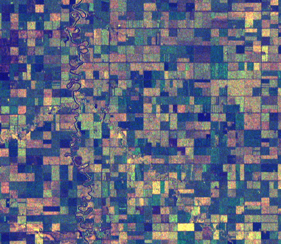
Radar image of the Red River Valley / Copernicus Sentinel data 2020
A combination of optical and radar satellite imagery allowed SatAgro to capture the 2020 harvest as it happened, in dynamic detail. The base output of the system are field-specific harvest maps. These are aggregated into regional percent complete values, in accordance with the ACSC’s internal organization and business needs. Regional figures where then presented on charts and maps on an easy to use dashboard.
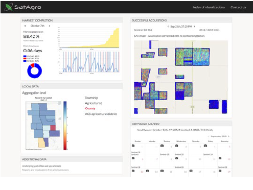
“The harvest completion information SatAgro was able to generate gave us greater confidence in our crop and harvest progress predictions” says the ACSC’s General Agronomist. “The SatAgro team has been very open to learning our business and the unique way we look at things, the information we need, and the structure in which the data is presented”.
“SatAgro’s aim is to assist the ACSC by delivering accurate and timely data. We are happy to contribute our small puzzle piece to this immense operation” said Stefan Jozefowicz. The ACSC harvest detection project is part of SatAgro’s offer to institutional clients – large scale agroanalytics, with components ranging from precision agriculture to yield prediction.

 Platforma