Are you ready for Variable Rate Application?

11/10/2020

The just published new version of SatAgro includes a set of functionalities that will help you to see to what extent your farm is ready for a comprehensive implementation of precision treatments, as well as what data sets are integrated with the borders of individual crop fields.

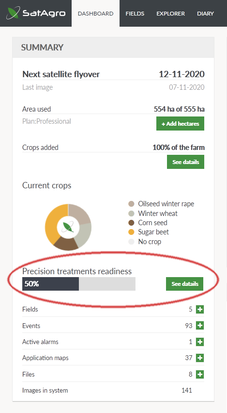
The technologies available nowadays allow us to obtain a lot of information about varying conditions within the fields – their soils, crop, yielding. In response to this constant technological progress, we have developed a number of tools that allow farms to benefit from it. However, the practice of working with agronomists allows us to conclude that the inclusion of just four key elements of field monitoring allows most of the benefits of precision farming to be realised.

These elements are: (1) satellite monitoring of crops, (2) soil survey, (3) field management zones, (4) cropping history.

After logging in to the SatAgro service, a new section “Precision treatments readiness” is visible on the Desktop. It contains a progress bar which informs, in percentage values, about the degree of completion of these key data sets (averaged over all crop fields).

 
VRA_readiness_SatAgro

Satellite monitoring of crops
In addition to crop scouting, satellite images, and SatAgro tools based on them, make it possible to create Variable Rate Application maps, both for individual crop fields and groups of fields. Satellite monitoring is of paramount importance for the optimisation of fertilisation with nitrogen, the availability of which is so variable that periodic soil surveying can only capture it to a small extent. At a time of increasingly strict regulation of environmental impact, including specific guidelines of the Nitrates Directive, taking into account the variability of the state of the crop allows to maximise the usefulness of fertiliser within the set limits.

Soil survey
Soil survey is traditionally considered to be the cornerstone of precision farming. The SatAgro service includes tools for dividing the field into sampling zones on the basis of internally consistent, and therefore more representative, zones.  This allows soil variability to be better captured than with a simple approach based on a regular grid. A number of tools are then available to create precision treatments once the samples were analysed and the results have been entered into the SatAgro user account.

Field management zones
Field management zones are a reflection of the long-term trend in yielding of different parts of a crop field. Unlike the current monitoring, which allows for a quick response to emerging anomalies, management zones are a kind of summary of many observations. They are particularly useful for planning precise treatments when the crop is not yet present, when it has just begun to develop, or when current satellite images are not available. The SatAgro service allows averaging satellite maps as the basis for zone designation (Map Mixer tool). However, sometimes even one good image, e.g. from the dying out phase of the crop during a dry season, perfectly reflects the spatial variation in crop field productivity. In the era of increasingly efficient mapping of yield during harvesting, the data obtained in this way can also be used as a basis for determining field management zones.

Cropping history
The correct analysis of satellite imagery and other maps is facilitated by knowledge of the history of the crop field and the factors influencing yield, especially weather conditions. The SatAgro service enables the visualization of the cropping history, the course of the crop condition, and key agro-meteorological variables that shape it. It is possible to compare many seasons, as well as to define alarms related to particular variables. The introduction of sowing dates makes it possible to automatically count such key parameters as Growing Degree Days and accumulated precipitation, which are important for the planning of treatments and influence yields. The introduction of yield records helps to analyse their dependence on monitored variables and supports the development of forecasting models.

The availability of this information for each crop field is summarised in a table visible by clicking on the “Details” button on the Desktop. Each element of the list is linked to the SatAgro service modules that support the management of this information. From here you can easily jump to the section for the design soil sampling zones and importing the soil survey results, to the module that allows you to designate field management zones, or to a view for an easy completion of crop rotation information on your farm.

VRA_readiness_SatAgro

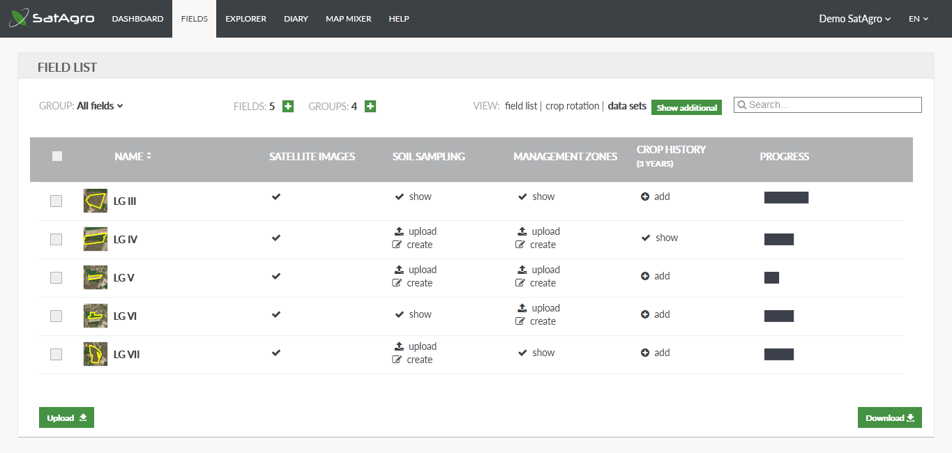
Clicking on the “Show additional” button allows you to visualize the availability of other layers of spatial information, such as yield maps, soil scanning results or drones data. This option is particularly useful for farms that have such a large collection of data integrated in the SatAgro service that it is difficult to remember which elements are available for particular crop fields.