Fresh news from SatAgro

Farm data management

What types of data should I use?

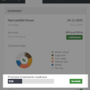
SatAgro will help you to see to what extent your farm is ready to implement precision treatments, as well as what data sets are uploaded for each field. Modern technologies allow you to get a lot of information about our fields – their soil conditions, field condition, yielding. However, four categories of information are particularly important for introducing precision farming techniques to your farm: satellite monitoring, soil sampling results, field management zones, crop history. In the Dashboard tab, you will find a section called “Precision treatment readiness”. This progress bar shows how much of the data you have already integrated…

Crop history

SatAgro lets you compare the current season to data from previous seasons. Keeping track of crop history is crucial for benefiting from past experience in future decisions. Filling out your farms crop history helps SatAgro calculate crucial variables, such as the crop-specific Growing Degree Days (GDD) variable, calculated from the sowing date onwards. Crop history from previous seasons can be easily added in the “Fields” tab. First, in the top right switch to the “Crop rotation” view to display a table of fields and seasons. Click “add” where you want to enter crop information. This will bring up a window with the crop history…

Grouping fields

In some cases, it’s useful to operate on multiple fields instead of just one. Field groups are a useful way to accomplish this in SatAgro. Fields with a given crop will automatically be placed in one group (e.g. “Winter wheat”, “Corn”). If you want to create a group using other criteria (e.g. “Winter wheat fields in the west of the farm”), simply tick the boxes next to your fields of choice in the “Fields” tab and click the “+” sign next to the Group count. You will be asked to name the group, and you can provide a short description…

Uploading your own data

If you have your own farm data, e.g. yield maps or soil and agricultural maps, we can upload them into the system for you. User data can then be displayed in the “Explorer” and in some cases transformed into precision treatments. To upload data, go to “Explorer”. In the upper left corner, from the “Show on map” list, select “Import new layer”. You will now see a window in which you can select the type of data you want to upload, e.g. yield maps. This is to make the process easier for the employees integrating your data into SatAgro. After…