In the light of the unprecedented challenges of the 21-st Century, our overriding aim is to improve sustainability and profitability of crop production. We achieve this by democratising the use of satellite monitoring in farming and by creating intuitive and scalable digital farming tools.
The SatAgro platform allows farms to save money while improving their environmental footprint and climate resilience. SatAgro is:
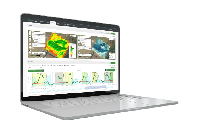
With satellite data, it’s easier to monitor the state of the crop in each field. Highlight the variabilities in plant growth and plan appropriate, tailored agronomy, from establishment to harvest.
Need anything we haven’t mentioned? Please contact us.
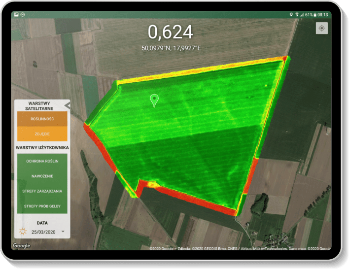
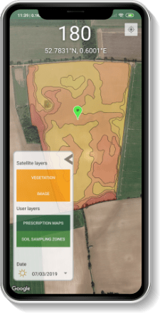
Map area – observe variations in crop development within the selected field, and gain insights into the long-term characteristics of the field, such as soil and moisture dynamics.
We are experts in Earth Observation, mapping technologies and environmental modelling, and we work closely with partners representing all aspects of modern agronomy.
SatAgro is amongst pioneers of operational satellite data use in individual farms – the platform has been online since 2015. Meanwhile, availability of Space-based observations has increased immensely, but the sector is still far from mature and it has been evolving fast. And so has been SatAgro. We adapt and strive to boost your overall performance, with extra focus on precision treatments, connectivity, and environmental impacts.
Hundreds of farms have been teaching us what is important to them, and the SatAgro platform is a reflection of this. Today we can support you with first-class monitoring of your crops and their environment, as well as the management of all nutrients and agrochemicals: from mapping productivity and profitability to designing a soil survey and fertilisation plans, to sending individual smart prescription maps directly to your machinery and exporting documentation for regulatory compliance. All of this in one comprehensive platform. Plus a promise that every year there is more.
Join us in making crop production more efficient and sustainable!
The SatAgro service is intuitive and easy to use. Satellite images allow for even better use of the machine park we have. It is possible to compare different layers with data about our fields, such as soil fertility, the amount of seeds planted or the yield, thanks to which it is possible to analyze them in a comprehensive manner. Thanks to the integration of the service with the John Deere Operations Center, data transfer is simple and fast.
Łukasz Wlekły
Farm owner and agricultural entrepreneur
SatAgro is an interesting system with many practical uses. Thanks to the SatAgro app, we’ve been able to achieve substantial reductions in our use of fertiliser.
Dr Jaroslaw Grocholski
Vice President
PPHiU ARENDA Sp. z o.o.

SatAgro is a powerful tool with which I can control, analyse and manage my plots thanks to its simplicity and ease of use, providing the most important data, such as satellite images or weather, in a simple way. In addition, thanks to the possibility of generating a temporal evolution of the crop's vegetative index, it has allowed me to reduce fertilizer doses by 20%, obtaining a 15% higher yield.
Marcos Esteve
Ing. Mechanic and farmer
Try SatAgro tools, both on the web and the mobile version: 1 crop field up to 120 ac
Satellite monitoring sits comfortably alongside other tools such as drones or ground-based systems, data from which we regularly integrate with user accounts. But satellites offer two important advantages: affordability and simple, whole-farm coverage in one go. An ideal basis for many precision treatments, our satellite maps even allow you to estimate and compare alternative treatments before executing the treatment.
Inappropriate or incorrect use of agrochemicals can affect farm profitability and environmental integrity. But a set of SatAgro prescription maps make it possible to use the same amount of inputs more efficiently, or to reduce doses locally without any loss in yields or chemical efficacy.
Year after year, we deliver images from more and more satellites. Two factors affects data availability: satellite type and cloud cover. In practice, during the season we provide at least a dozen maps. Satellite flight dates are published on the SatAgro dashboard. SatAgro Premium brings with it commercial data, more frequent updates and a higher image resolution.
The connection to SatAgro is encrypted and our servers are secure. We will never sell to anybody any of your personal data. We might use some aggregated crop-related data, entered by the users, to train algorithms and sometimes to publish scientific papers. In this case we ensure that individual user information is not visible, unless we get a written permission. This approach enables us, and you, to participate in the development of technologies that support farms world-wide.
Everything you create or we deliver to you within the platform can be exported in industry standard formats. This is particularly important in the case of prescription maps for precision treatments. SatAgro files are compatible with sprayers, spreaders and terminals from leading manufacturers, including John Deere, Trimble, TopCon, Amazone and others. If you operate John Deere, Trimble or AGCO equipment at the farm, you can send files wirelessly to a machine in the field. The same applies to the users of Agrirouter.
Markers on the map indicate in which countries the SatAgro Platform is currently available. In the rest of the world, we can launch SatAgro within a few days (contact us about this).

Czech Republic, Lithuania, Poland, Slovakia, United States of America
The real strength comes from the ability to take up the challenge together. We are proud to partner and integrate with You.
Want to find out more about how you could benefit from satellites? Send us a message.
ul. Żwirki i Wigury 93
02-089 Warsaw
Poland
Joanna: 570 000 941
Konrad: 533 333 064
Dominik: 576 666 915
 office@satagro.net
 @SatAgroEN
 SatAgro
 SatAgro
NIP: 7010639032
REGON: 365886156
Your message has been sent successfully!
